Master plan
Thirty-seven acres, fourteen towers, one landscaped core
The Prestige Pulimamidi master plan organises 37 acres into 14 residential towers, a central landscape core, a township clubhouse and a two-level basement parking system serving the entire site. LINQ by Raghava is useful for the site-planning lens because buyers should read open space, movement, parking, and amenity placement as everyday-use details, not brochure decoration.
| Element | Provision |
|---|---|
| Total land area | 37 acres |
| Residential towers | 14 |
| Tower format | 2 basements + Ground + 27 floors |
| Total apartments | 2,800 |
| Density | About 76 units per acre |
| Parking | Two full basement levels |
| Configurations | 2 BHK, 3 BHK (2T), 3 BHK (3T), 4 BHK |
| Size range | 1,100 - 2,600 sq ft |
| Approving authority | HMDA |
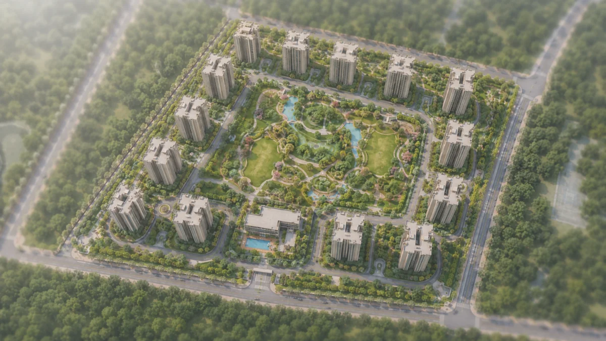
The drawing
Prestige Pulimamidi Master Plan - towers around a green core
The 14 towers are arranged around a central landscaped core rather than in a uniform grid. Towers set around a core mean the majority of apartments look onto open landscape rather than into a neighbouring tower's windows - in a grid layout at this density, a substantial share of homes would face another building across a narrow setback.
Staggered placement also allows air movement through the site rather than creating sealed courtyards. On a south-Hyderabad site with long hot months, cross-ventilation through the site plan is worth as much as any mechanical system. And a layout arranged around a core allows construction to proceed in clusters while completed clusters are occupied, with construction traffic routed on the perimeter loop rather than through the residential core.
At 27 floors, inter-tower spacing determines whether a project feels open or oppressive. HMDA setback requirements set the floor; a 37-acre site with only 14 towers allows spacing well beyond that minimum. This is where the density figure earns its keep - the same 2,800 units on 20 acres would be a substantially different living experience.
Land use
Where the thirty-seven acres go
A township of this scale allocates its acreage across four broad categories. The proportions below reflect the planning logic that a 76-unit-per-acre density at 27 floors makes possible. The number that matters is the first one: fourteen towers at 27 floors put a very large amount of built area on a very small ground footprint, so roughly four fifths of the site stays unbuilt at ground level.
| Land use | Approximate share | What it covers |
|---|---|---|
| Tower footprints | 18 - 22% | Fourteen tower plates at ground level |
| Landscape and open space | 40 - 45% | Central green spine, pocket parks, tot lots, walking loops |
| Amenity and clubhouse | 6 - 8% | Clubhouse envelope, courts, pool decks |
| Roads, driveways and circulation | 15 - 18% | Perimeter loop, drop-offs, service access, fire tender path |
| Services and utilities | 5 - 7% | STP, water treatment, substation, DG yard, waste handling |
Why a spine, not pockets
- A continuous green corridor gives residents somewhere to walk to
- A route with a beginning and an end, long enough for a genuine walk
- Fragmented pockets of grass between towers give residents somewhere to look at
- Across 2,800 households the difference in daily use is substantial
What the spine carries
- Walking and jogging loops
- An amphitheatre for community events and party lawns
- Themed gardens, reflexology paths, seating groves and shaded pause points
- The pedestrian network connecting towers, clubhouse and gates without crossing roads
Distributed pockets as well
- Each tower cluster gets its own pocket park and tot lot
- On a 37-acre site, a play area at the far end is functionally not there
- So the plan repeats them near every cluster
- Supervision from a nearby bench rather than an expedition
Circulation and services
Two basement levels, a perimeter loop and a small town's worth of services
Basement access is by dedicated ramps at the site perimeter, keeping vehicle movement at the edge. Each tower core connects directly to both basement levels by lift and stair, so residents move from car to home without surfacing. A perimeter loop road carries all resident and visitor vehicle movement around the outside of the residential core, feeding the basement ramps and tower drop-offs; the interior is not a through-route.
Fire tender access paths are planned to reach every tower, with turning radii and hardstanding sized for the equipment required at 27 floors. At this height, fire access is a design constraint rather than a checkbox - external rescue is limited above a certain level, which is why internal pressurised staircases, sprinkler coverage and refuge floors carry the load.
Water
- Underground sump capacity sized for the full population with buffer
- Pumped to overhead tanks on each tower
- Pressure zoning so upper floors receive supply at usable pressure
- Without over-pressurising lower floors
Waste water and rain
- On-site STP sized for full occupancy
- Treated water returned to landscape irrigation and flushing
- Rainwater collection from roofs and paved areas to distributed recharge pits
- In a district that depends on groundwater, recharge is how the aquifer stays viable
Power and storm water
- Dedicated substation with transformer yard
- Ring-main distribution to tower cores
- DG backup for common areas, lifts, pumps and essential apartment loads
- Graded drainage sized for peak monsoon intensity - the basements must stay dry
Sustainability infrastructure
Treated water reused for landscape irrigation and toilet flushing cuts fresh-water demand materially, and site-wide rainwater collection and recharge supports the aquifer under a 37-acre footprint. Solar provision serves common-area loads - corridor and landscape lighting, pump sets and clubhouse base load - and organic waste is processed on site with segregation at source across all 2,800 homes, reducing what leaves the site to landfill.
Native and adapted planting reduces irrigation demand, while tree cover across the central spine and pocket parks moderates the surface temperature of the site, a meaningful comfort factor in this climate. Orientation and shading are considered at the tower-plate level to reduce solar gain on the worst-exposed elevations, lowering cooling load over the building's life.
Serving the location
A township that has to do the neighbourhood's work first
Kandukur is a greenfield corridor. There is no established social infrastructure adjacent to the site, and there will not be for several years. That reality drives the master plan's logic. The reason the amenity programme is extensive, the reason the landscape spine is continuous, and the reason two basement levels were excavated to free the surface, is that this township has to be substantially self-sufficient in the years between handover and the corridor maturing around it.
Residents will not have a mall, a multiplex or a public park nearby at first. They will have 37 acres of which roughly four fifths is open at ground level, a clubhouse sized for a township, and a landscape core long enough to walk properly. That is the master plan doing the work the neighbourhood cannot yet do.
As the Future City programme builds out - the health and wellness city near Kandukur, the commercial spine along the Srisailam Highway, the sports city - the township's self-sufficiency becomes a bonus rather than a necessity. But it has to be there first.
Prestige Pulimamidi Master Plan - Frequently Asked Questions
Thirty-seven acres organised into 14 residential towers at 2 basements plus ground plus 27 floors, delivering 2,800 apartments around a central landscape spine, with a township clubhouse and a two-level basement parking system serving the entire site. Density works out at roughly 76 units per acre.
Roughly four fifths at ground level. Tower footprints take only 18% to 22% of the site because 14 towers at 27 floors put a very large amount of built area on a very small ground plate - which is the entire point of building vertically. Landscape and open space take 40% to 45%.
Three reasons. View retention: towers set around a core mean most apartments look onto open landscape rather than into a neighbouring tower's windows, where a grid at this density would face a substantial share of homes across a narrow setback. Wind and light: staggered placement allows air movement rather than sealed courtyards. And phasing: construction can proceed in clusters while completed clusters are occupied, with construction traffic on the perimeter loop.
Parking for 2,800 apartments plus visitors, entirely below grade - at 1.3 to 1.5 bays per home that is upward of 3,600 to 4,200 spaces. Accommodating that at surface level would consume most of the site. With vehicles below ground the surface plane belongs to landscape and pedestrians: no bays lining internal roads, no reversing vehicles beside play areas, no heat-radiating asphalt fields.
Yes, and that is the point. Two-level excavation across a large footprint is expensive and slow, with waterproofing, ventilation, ramp geometry, fire compartmentation and drainage all becoming significant engineering items. A developer choosing this route on a 37-acre greenfield site, where surface parking would have been far cheaper, is making a product-quality decision.
A continuous landscaped core running through the centre of the site rather than landscape distributed as leftover space between buildings. It carries walking and jogging loops, an amphitheatre, party lawns, themed gardens, reflexology paths and seating groves, plus the pedestrian network connecting towers, clubhouse and gates without crossing vehicular roads. Each tower cluster also gets its own pocket park and tot lot.
By making the township substantially self-sufficient for the years between handover and the corridor maturing. Residents will not have a mall, a multiplex or a public park nearby at first. They will have 37 acres of which roughly four fifths is open at ground level, a clubhouse sized for a township, and a landscape core long enough to walk properly. That is the master plan doing the work the neighbourhood cannot yet do.